 |

Satellite Imagery For more information please contact our business development unit.... +44 (0) 1962 855469 or email us...
|
Geographic Information System based mapping... We can produce in house satellite image and air photograph based mapping which can include GPS ground control to provide rectified, geo referenced and gridded base maps for use in planning, exploration, design and development of client projects. Ideal for large scale planning, exploration in oil & gas or mining, route surveys for roads, rail or pipelines, feasibility through to detailed engineering or just as built records. Thematic mapping linked to database(s) can provide a quick cost effective first step and then become a valuable tool in any project. Can be followed up at a later stage by more detailed surveys. Thematic maps are a powerful tool .. We also have a strategic alliance with Infoterra (UK) to supply, process, interpret and produce satellite / air photograph based GIS mapping. Our alliance offers a unique remote sensing resource and can supply discounted satellite imagery and air photography from an extensive library or specially flown missions together with processing, interpretation and thematic mapping service by the professionals of INFOTERRA a European Space Agency company and Europe 's largest supplier of satellite data. INFOTERRA also has own airborne sensors and cameras, including analogue and digital cameras, digital line scanners, airborne laser scanning LIDAR, spectral analysis. Satellite Imagery
|
|
|
||
 |
||
 |
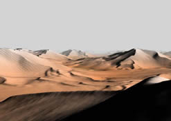
View Sample Images + Maps |
|||||
| IKONOS | |||||
| 3D Fly Through | |||||