|
|
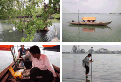
River, coastal and shallow marine hydrographic surveys
Locally hired shallow draft boatscan be equipped with our own personnel and equipment, including 3 No. echo sounders up to 100m depth capability, automatic digital tide monitoring equipment, DGPS positioning and navigation equipment.
All equipment fully calibrated.
Single & dual frequency echo sounders, CEEDUCER Pro.
 Positioning & tracking using PSION navigation system with CEEMAN software Positioning & tracking using PSION navigation system with CEEMAN software
 linked to real time DGPS Leica 1200 series base station and rover units and linked to real time DGPS Leica 1200 series base station and rover units and
ASHTEC equipment.
Tide monitoring using CEETIDE.
Calculation of tide constants mean sea level ( MSL ), Chart Datum ( CD ), Lowest Astronomical Tide ( LAT ), Highest Astronomical Tide ( HAT ) and other tide based parameters.
Typical projects have included:
Ports, harbours, berths & marine terminals.
Ship navigation channels
Coal & oil / gas loading & unloading facilities
Breakwaters
Dredging
Underwater Pipelines & cables
Position fixing for drilling & construction works
Feasibility, design & construction engineering works
Environmental
River and coastal crossings bridges, embankments, road, rail & pipeline / cable crossings.
|