 |
 |
Digitising Service
2D CAD - Plans & Cross Sections Thematic Mapping Grading Plans & Engineering Design Earthworks & Road Design Cut / Fill Balance Quantities & Volume Calculations 3D Modelling Walk or Fly Through Animations Plotting Service For more information please contact our business development unit.... +44 (0) 1962 855469 or email us...
|
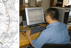
Visualise your project with 2D maps, plans and sections... Trikonex uses our associate CAD / GIS bureau based in In Indonesia which has the latest computer aided drafting technology, GIS and 3D visualisation software to enable clients to better understand & visualise their projects. " Added value " is provided by use of " low cost " resources which often give clients a a " time advantage ". CAD work can be produced overnight and be with a client the following morning! Our experienced staff can undertake a wide range of CAD work ranging from digitisation through to 2D plans and cross sections through to more complex 3D modelling and walk throughs. Our surveyors are supported by our CAD / GIS team equipped with latest high spec. computing power and latest ACAD, Softdesk & GIS software for
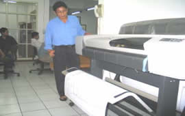
Visualise your project in 3D... We can provide full photographic or visual animations which enable project walk throughs or fly throughs. Advances in hardware & software have reduced cost of modelling & made 3D visualisation commercially viable for any sized project. Good quality, photo realistic images and animations can be used by the client for presentations, reports, planning and project visualisation that takes CAD & 3D visualisation to a new and higher level. Everyone needs a good base map... We also provide overnight CAD drafting services where data can be processed & drawings produced using the "time zone" difference. Survey or client companies can send us data for processing & drafting at end of each day in countries such as UK and we can work on these overnight and submit the following day for finalisation & QC checking. Large cost & time savings can be made which in turn gives you faster turnaround in drawing production and vastly improves costs and profits!
|
|
||||